Dispatch
Old Linn Creek, Missouri: Walk the Town Under the Lake
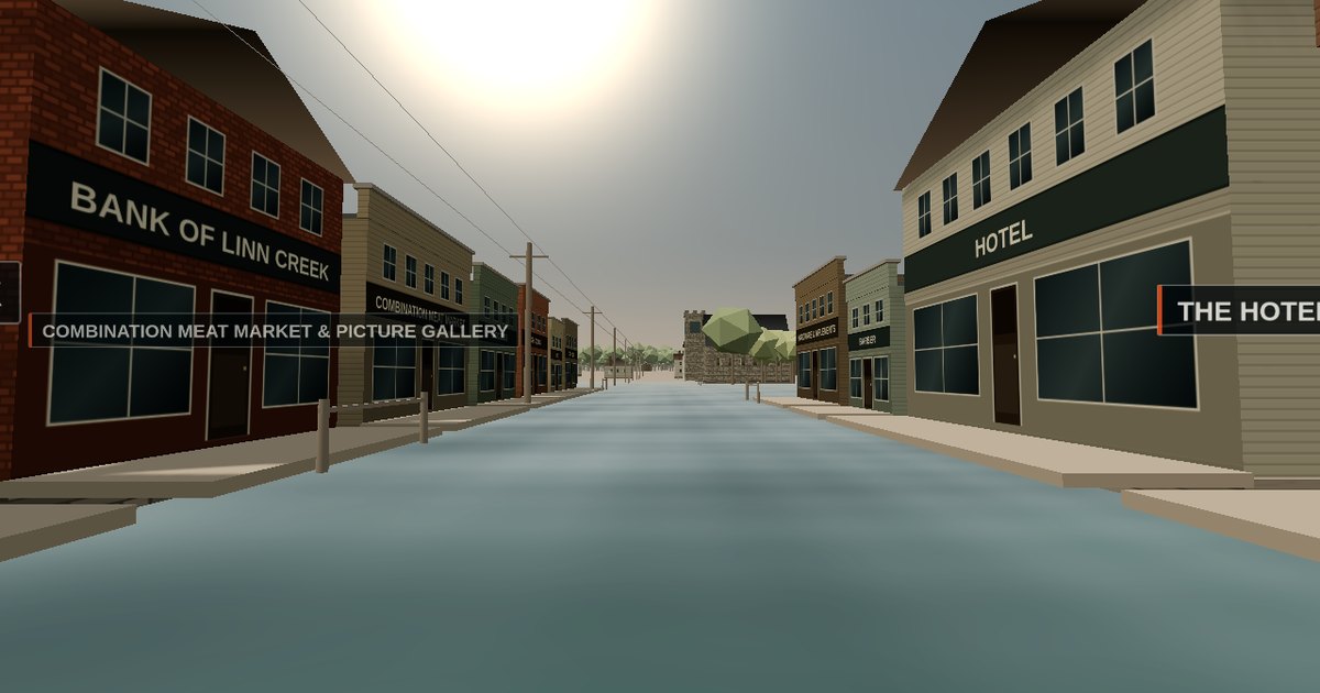
There is a town under the Lake of the Ozarks. Most people around here know that much. Fewer know that the lake did not kill it.
I rebuilt Old Linn Creek as something you can walk through in a browser, and set the whole end of it — the demolition and the flooding, in that order — on two sliders.
What town is under the Lake of the Ozarks?
Old Linn Creek, Missouri, seat of Camden County from 1855 until 1930.
It sat where Linn Creek runs into the Osage River, at the head of practical navigation on that river, thirty-one river miles above the spot where Union Electric would build Bagnell Dam. Benjamin R. Abbott opened the first store in 1841. The 1920 census counted 431 people. The 1930 census counted 553, and that was the last one it got.
It was really two settlements. Lower Town sat at the mouth of the creek where the steamboats landed. Upper Town stood about half a mile up the valley and held the courthouse square. Most accounts flatten the two together, which is how you end up picturing one long street instead of a town with a working waterfront at one end and the county’s business at the other.
How Bagnell Dam took Old Linn Creek: the winter of 1930-31
The water arrived in 1931. The town was already gone.
Camden County voted on November 4, 1930 to move the county seat up the hill to Camdenton. Over that winter, crews took Old Linn Creek apart by hand. Frame buildings were burned, storefront by storefront. Anything that would not burn had a cable run to it and was hauled over by teams and tractors. There is a photograph from February 1931 showing a cable strung through a hole knocked in the Methodist church’s stone bell tower, waiting to pull it down. The congregation had already taken out the stained glass, the pews, the flooring and the bell, and carried all of it up the road to the new Linn Creek, where it still is.
Union Electric bought or condemned everything below the 660-foot line. A fringe of about a dozen houses sat above it on the bluff. Those are still standing.
So the lake did not drown a town. It flooded a cleared lot.
Inside the 3D reconstruction of Old Linn Creek
You start at the foot of Main Street looking up it. Storefronts run down both sides under the posted awnings the photographs show, with the Linn Creek Mercantile Co. two stories of brick on the corner and CLOTHING DEPARTMENT painted across its whole upper wall in letters you could read from the end of the street. The Camden County courthouse stands on its square. The three churches sit within half a block of each other, which is where the record puts them.
Three controls do the real work.
The winter. A slider runs the town through the demolition. Frame buildings burn and go, with smoke standing over whichever quarter is going that week. Cables appear on the masonry. The churches go last, and the Methodist last of all. The bluff houses never come down, because they never did.
The lake. A second slider raises the pool from the pre-dam Osage at 598 feet to full pool at 660. Main Street ends up about thirty-two feet down. You can keep walking while it happens.
The photographs. Five tripod markers stand where I estimate the cameras stood. Walk to one, press C, and the surviving photograph fades over your view on a slider, so you can judge the reconstruction against the evidence yourself instead of taking my word for it.
How I built it: Claude, WebGL, and five photographs
The whole thing is one self-contained HTML file running Three.js. No download, no plugin, no game engine.
I built it with Claude across a long working session, and the honest version of that story is that the research drove the code rather than the other way round. Elevations came first: the world is anchored so that ground level zero is 600 feet above sea level, full pool is 660, and the pre-dam Osage ran at 598. Everything else — how deep Main Street ends up, which houses survive on the bluff, where the waterline sits at the steamboat landing — falls out of those three numbers instead of being art-directed.
Facades are drawn as canvas textures at a fixed 48 pixels per metre, so clapboard courses and brick and painted signage stay at consistent real scale across a hundred buildings without modelling a single window.
The five surviving photographs caused the largest revision. An early version had bare storefronts and a thin scatter of trees. The photographs show continuous posted awnings with sawn brackets down both sides of the street, automobiles angle-parked at the kerb, and a valley so heavily timbered that the buildings sit down inside it. All of that got rebuilt.
The part I would tell a client about is the verification. WebGL cannot be checked by reading the code. I stood up software OpenGL and rendered actual frames, which immediately surfaced three bugs that every logic test had passed clean: a fullscreen shader quad that drew nothing, a vignette using smoothstep with its edges reversed, and a tree density that had buried the entire town when seen from above. That is the same discipline behind the automation work I do at Thane Operations — build the thing, then build the harness that proves the thing works, because confident output is not the same as correct output.
Sources: what is documented and what is not
Every building card in the reconstruction says whether it is documented or representative. Twenty are documented, three are not.
The Camden County courthouse is the best-attested structure in town. Dimensions, contract price, the January 1902 fire that gutted it, the 1906 rebuild on the surviving walls, and Union Electric’s $60,000 settlement with the county all come from Marian Ohman’s courthouse survey for MU Extension by way of the county court record. The Mercantile’s entire face comes off one photograph. The three churches come from Michael Gillespie’s description of images in T. Victor Jeffries’ Before the Dam Water (1974).
Street geometry is schematic. No measured survey of the town survives that I could find. Where the record ran out I used ordinary Ozark vernacular of the period and labelled it as such rather than quietly filling the gap.
One disagreement I left standing instead of settling: the surviving postcards say the site now lies under fifty feet of water, and one appears to claim eighty. Gillespie says thirty to forty. Full pool is 660 and the Osage ran about 598 here, so eighty feet would put Main Street below the bed of the river. I graded it to about thirty-two and wrote the argument into the sources sheet.
Common questions about Old Linn Creek
When was Old Linn Creek flooded?
The waters rose in 1931, after Bagnell Dam closed. The town itself was dismantled the previous winter, between the November 4, 1930 removal vote and the spring.
How deep underwater is Old Linn Creek?
Main Street sits roughly thirty to forty feet below full pool, which is 660 feet above sea level. Popular postcards claim fifty and even eighty feet, but eighty would place the street below the original bed of the Osage.
Can you dive or see Old Linn Creek today?
There is very little left to see. The town was burned and pulled down before it was flooded, so the site is foundations and rubble rather than standing buildings, and the lake has poor visibility at depth.
Where did the people of Old Linn Creek go?
Most went to Camdenton, purpose-built on higher ground as the new county seat, or to the new Linn Creek nearby. The Methodist church’s bell, pews, flooring and stained glass went with them.
Is anything from the old town still standing?
About a dozen houses on the bluff sat above the 660-foot line Union Electric bought out, and were never taken.
Lake of the Ozarks history, from someone who lives here
I write from the Lake of the Ozarks, and this is local history rather than a research exercise for me.
If you knew somebody who lived in Old Linn Creek, or you have photographs that never made it into the published record, I would like to hear about it — get in touch. Corrections are welcome too, and the reconstruction is built so they can be applied.
The Camden County Historical Society in Linn Creek holds the photographic collection and still sells Jeffries. If any of this interests you past the browser window, that is the door.
-30-